Geoscience Services

Serving Western Canada

Advanced Sub-Surface Mapping for Utility & Infrastructure Projects

Higher Accuracy

Deeper Reach

Our Geoscience services utilises state-of-the-art geophysical equipment to deliver high-resolution subsurface imaging and mapping. 

Whether you’re planning new utility installations, validating existing infrastructure, or assessing site conditions for construction or remediation, our tools and expertise provide you with trusted data to make informed decisions.

Registered

& in Good Standing

Association of Professional Engineers and Geoscientists of Alberta

We are aligned with the standards set by APEGA reflecting our commitment to professional excellence, regulatory compliance, and responsible engineering practices.

ISNetworld

We are proudly registered with ISNetworld, demonstrating our commitment to meeting industry-leading standards for safety, compliance, and operational excellence. This registration ensures our clients can trust that we follow strict protocols and maintain the highest level of accountability on every project.

Our Geoscience Services

That Set the Standard for Excellence

eLogging Wireline Unit

Our eLogging fleet includes a robust 1-ton wireline unit and a lightweight, UTV- or helicopter-portable winch with 4-conductor line, enabling precise logging to depths of approximately 2000 ft (600 m), while the advanced CSS Geotechnical system delivers real-time data, on-site field logs, and professional full-color reporting for complete well documentation.

GR-RES-SP-Caliper eLogging

Our servicess provide elogging that  utilizes Gamma Ray, Spontaneous Potential (SP), Resistivity, and Caliper tools to generate detailed subsurface profiles that identify lithology, permeability, fluid characteristics, and borehole conditions, supporting accurate aquifer evaluation, optimized screen placement, and long-term groundwater management.

Borehole Caliper and Videos

We provide high-resolution downhole camera inspections to depths of approximately 750 ft (225 m), combining downhole and side-view imaging with caliper measurements to identify casing integrity issues, fractures, corrosion, obstructions, and borehole irregularities for accurate diagnostics and effective well planning.

Acoustic WaveForm Logs

Acoustic waveform logging measures sonic formation travel time using a 3-foot transmitter/receiver spacing to evaluate formation slowness, porosity, and lithology while also assessing cement bond quality, detecting voids or channeling behind casing, and supporting well integrity analysis and optimized completion design.

NEW

tTEM Resistivity Survey

Towed Transient Electromagnetic Near Subsurface Surveys

Why This Matters

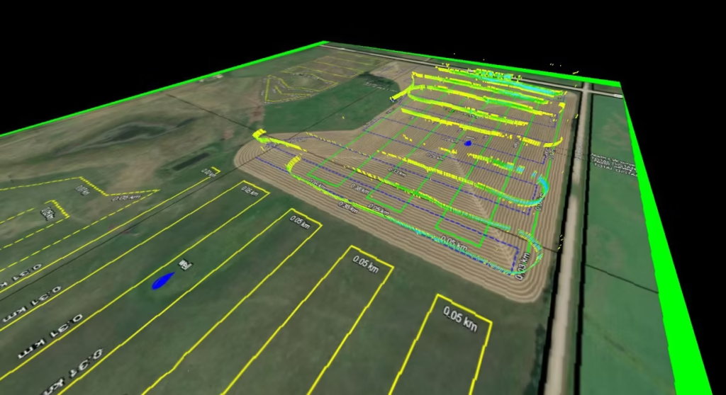
tTEM subsurface mapping provides a fast, non-invasive way to understand what’s happening beneath the ground, without the need for drilling or disruption. 

By collecting high-resolution data across your property, we can accurately identify aquifers, soil variations, and key geological features that impact water movement and land use. This allows landowners, engineers, and environmental professionals to make smarter, data-driven decisions with confidence.

At That Wireline Guy, we deliver clear, reliable subsurface insights tailored for projects across Central Albert helping you plan better, reduce risk, and avoid costly guesswork.

Accurate Results

We use industry-leading TEM technology to map what’s below the surface with clarity and depth — so you can move forward with confidence, not guesswork.

Faster, More Efficient

Our mobile setup covers ground quickly without disrupting your operations, giving you clear answers in less time and helping keep your project on schedule.

Affordable Scanning

You get advanced geophysical mapping without the inflated price tag. We provide high-quality results at a cost that makes sense for real-world projects and budgets.

Trusted eLogging & Geotechnical Surveys

Your Local Geoscience Experts

Accurate Surveys

for a Solid Foundation

Detailed Geo Reports

We don’t just ‘locate’ and hand over “there’s something here” scans. Our process involves collecting the data, interpreting the results, generating clear deliverables (maps, cross-sections, GIS-compatible outputs), and providing actionable insights for your next steps.

Safe and Accurate Ground Assessments

Whether it’s locating utilities, assessing ground conditions, detecting groundwater, or investigating well integrity issues, our services are designed to reduce risk, prevent surprises, and save you money in the field.

Trusted by Clients

Built on Precision

Insert testimonial here

Mason Luke

Our Client

Insert testimonial here

John David

Our Client

Client Testimonial

Insert testimonial here

Geo Surveying

Contact Today!