Our GR-RES-SP-Caliper eLogging services provide detailed subsurface profiles that help clients better understand water well conditions, identify productive zones, and make smarter decisions for well design and groundwater management. By combining multiple logging tools into one integrated service, we deliver a clearer picture of the formation, fluid conditions, and borehole geometry.
Our eLogging system uses Gamma Ray, Spontaneous Potential (SP), Resistivity, and Caliper tools to generate reliable downhole data that supports accurate aquifer evaluation, optimized screen placement, and long-term sustainable water management.
GR-RES-SP-Caliper eLogging is a multi-tool wireline logging service used to evaluate subsurface conditions in water wells. Each tool provides a different type of critical information, and together they create a comprehensive profile of the borehole and surrounding formations.
This combined approach helps identify:
Formation changes and lithology
Clay content and shale zones
Permeable intervals
Formation water characteristics
Aquifer zones
Borehole diameter changes and irregularities
By integrating all of this data, we help clients make informed decisions with greater accuracy and confidence.
Lithology & Clay Detection
Our Gamma Ray logging tool measures natural gamma radiation in the formation to help distinguish between different rock and sediment types. This is especially useful for identifying clay-rich zones, shale content, and changes in lithology throughout the well.
Gamma Ray data helps build a clearer understanding of the subsurface profile and supports more accurate formation interpretation when evaluating groundwater conditions.
Permeability & Formation Water Indications
Spontaneous Potential (SP) logging measures the natural electrical potential between the borehole fluid and surrounding formations. This tool is commonly used to identify permeable zones and provide insight into formation water conditions.
SP logs can help highlight intervals where water movement and permeability are more likely, making them valuable for groundwater investigations and water well planning.
Accurate GR-RES-SP-Caliper eLogging Services
Complete and Accurate Reports
Gain a complete and accurate understanding of subsurface conditions before making critical well decisions. By combining Gamma Ray, SP, Resistivity, and Caliper data, you can clearly identify lithology, permeable zones, aquifers, and borehole geometry, all in one pass.
This allows for precise screen placement, better well design, and improved water production, while reducing guesswork and the risk of poor-performing wells.
Sustainable Groundwater Management
support long-term, sustainable groundwater management and avoid costly mistakes. With detailed insight into fluid characteristics, formation properties, and borehole conditions, you can detect potential issues early and make informed decisions that improve efficiency and longevity.
This leads to better resource management, reduced need for rework or remediation, and more reliable performance over the life of the well.
Our Geoscience Services
That Set the Standard for Excellence
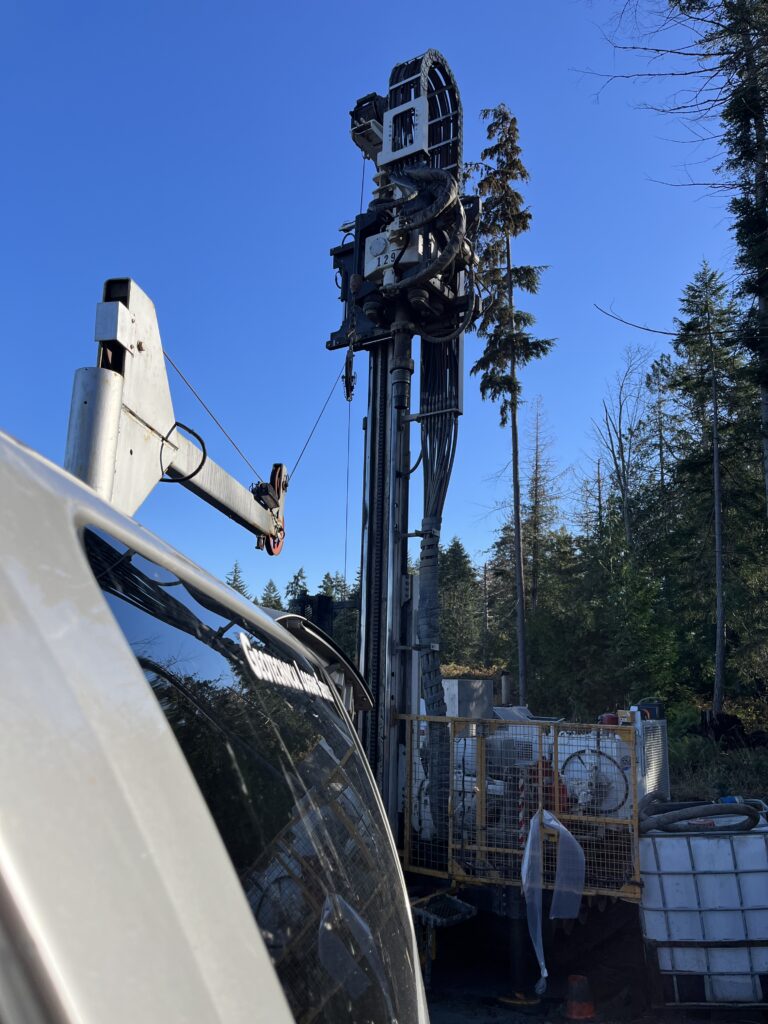
eLogging Wireline Unit
Our eLogging fleet includes a robust 1-ton wireline unit and a lightweight, UTV- or helicopter-portable winch with 4-conductor line, enabling precise logging to depths of approximately 2000 ft (600 m), while the advanced CSS Geotechnical system delivers real-time data, on-site field logs, and professional full-color reporting for complete well documentation.
Our servicess provide elogging that utilizes Gamma Ray, Spontaneous Potential (SP), Resistivity, and Caliper tools to generate detailed subsurface profiles that identify lithology, permeability, fluid characteristics, and borehole conditions, supporting accurate aquifer evaluation, optimized screen placement, and long-term groundwater management.
We provide high-resolution downhole camera inspections to depths of approximately 750 ft (225 m), combining downhole and side-view imaging with caliper measurements to identify casing integrity issues, fractures, corrosion, obstructions, and borehole irregularities for accurate diagnostics and effective well planning.
Acoustic waveform logging measures sonic formation travel time using a 3-foot transmitter/receiver spacing to evaluate formation slowness, porosity, and lithology while also assessing cement bond quality, detecting voids or channeling behind casing, and supporting well integrity analysis and optimized completion design.
Our ABEM GroundTEM Ralli system can typically detect subsurface features up to 150–200 metres deep, depending on ground conditions and coil configuration. This gives us far greater reach than most traditional utility-locating tools.
Yes. Even though the system is mobile and can be towed by a quad, it still uses a high-current transmitter loop and a multi-turn receiver coil. This is how it sends and captures electromagnetic signals to generate a 2D or 3D picture of what’s underground.
Absolutely. The GroundTEM Ralli is specifically built for oilfield, rural, and uneven terrain. It can be deployed with a quad/ATV and is rugged enough for remote sites, cutlines, access roads, and non-paved locations.